Point Lonsdale Lighthouse
Point Lonsdale Lighthouse looks over the narrow entrance to Port Phillip Bay. The Rip, as it is known, is one of the most notorious entrances to any bay in the world.
As shipping increased with the development of Melbourne in the early 1800’s the need for guidance to mariners was reconised.
History
Point Lonsdale received a private signal station in 1851 consisting of a pole mounted oil lamp on top of a sand dune to help ships negotiate its dangerous waters.
Four years later, a red pillar beacon was built to warn of Lonsdale Rock.
The first lighthouse was a wooden structure relocated from Shortlands Bluff in 1863 which remained in use until replaced by the present tower. It was finally dismantled in 1912.
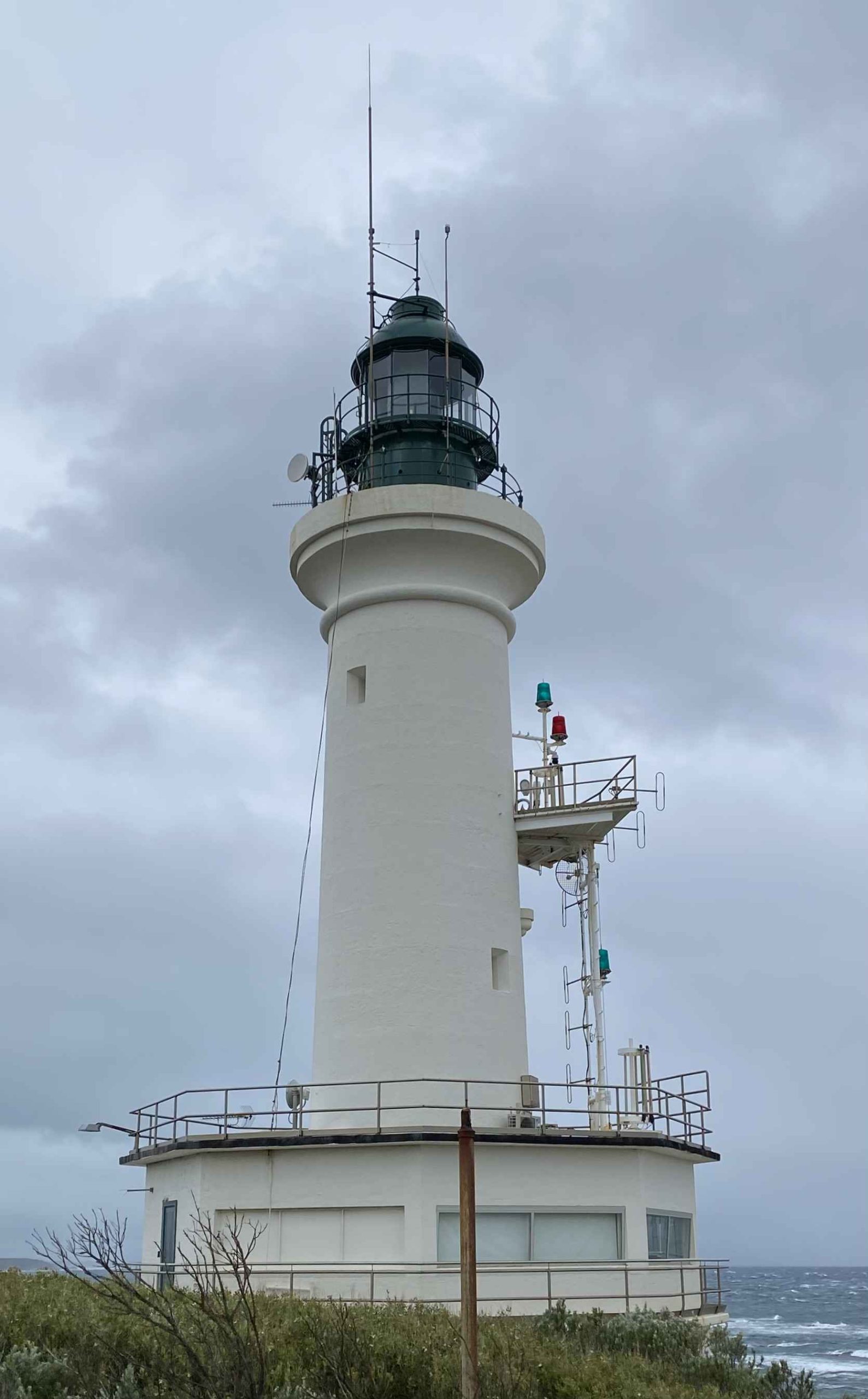
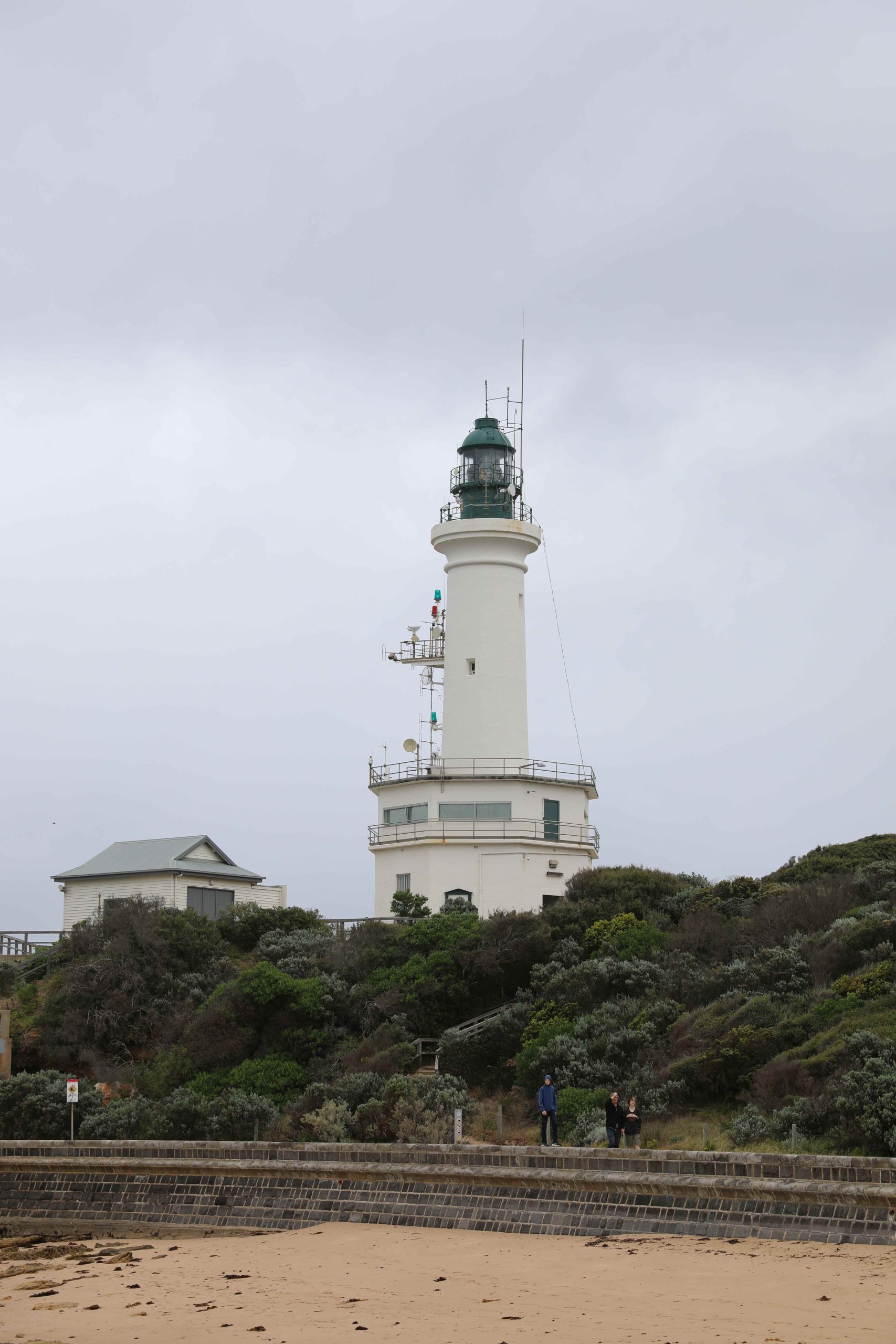
The current lighthouse was built in 1902. The 22 metre concrete tower is 2 metres thick at the bottom tapering to 1 metre thick at the top. In 1928 a foghorn was constructed in a shed below the lighthouse to warn of the approach in times of fog. The timing of the fog horn is is set to match the flash of the lighthouse. The Chance Brothers fog horn operated until 1993 when it was decommissioned. It remains in operating condition and is demonstrated on special occasions including lighthouse weekend in August each year.
In 1915 the lighthouse passed from the Victorian State Government to Commonwealth control with the formation of the Commonwealth lighthouse service. It was handed back to the state of Victoria in 1934 and classified as a harbour entrance light rather than a “Coastal Highway Light”. 1934 also saw the light converted from kerosene to electric illumination.
The base was altered with an addition in 1950 to provide a signal station. As part of this function below the main light, shown in a vertical line (west side) there are the red and green lights which indicate the tides: ingoing tide-first half, one fixed green light, second half, two fixed green lights. Outgoing tide-first half, one fixed red light, second half, two fixed red lights. One flashing green gives deep draft vessels outward clearance, one flashing red gives inward clearance.


© All images are copyright of their respective photographers and are not to be used without permission.
| Title | Address | Description |
|---|---|---|
Melbourne Leading Light Rear | 66 Beacon Vista, Port Melbourne VIC 3207, Australia | Melbourne Leading Light Rear |
Melbourne Leading Light Front | Bay Trail, Port Melbourne VIC 3207, Australia | Melbourne Leading Light Front |
Williamstown Timeball | Timeball Tower, Williamstown VIC 3016, Australia | Williamstown Timeball |
Point Gellibrand Pile Light | 31 Battery Rd, Williamstown VIC 3016, Australia | Point Gellibrand Pile Light |
West Channel Pile Light | 75 Bluff Rd, St Leonards VIC 3223, Australia | West Channel Pile Light |
South Channel Pile Light | 2591 Point Nepean Rd, Rye VIC 3941, Australia | South Channel Pile Light |
Eastern (McCrae) | 658 Point Nepean Rd, McCrae VIC 3938, Australia | Eastern (McCrae) |
Cape Schanck | Cape Schanck Access Rd, Cape Schanck VIC 3939, Australia | Cape Schanck |
Shortland Bluff (Black) | 66 Gellibrand St, Queenscliff VIC 3225, Australia | Shortland Bluff (Black) |
Queenscliff (Low) White | 133 Hesse St, Queenscliff VIC 3225, Australia | Queenscliff (Low) White |
Port Phillip Lights | 133 Hesse St, Queenscliff VIC 3225, Australia | Port Phillip Lights |
Point Lonsdale | 9-13 Point Lonsdale Rd, Point Lonsdale VIC 3225, Australia | Point Lonsdale |
Split Point | Federal St, Aireys Inlet VIC 3231, Australia | Split Point |
The lighthouse is also used from time to time as an alternate vessel traffic center located in the base of the tower for control of shipping through the Heads.
The lighthouse celebrated its centenary in 2002.
Keepers
We need your help in compiling a list of keepers for this lighthouse. If you have any information then send it to keeper@lighthouses.org.au.
Please include this lighthouse’s name, the keepers full name and what years they were keepers. Also include the same information for any other lights they were on.
Technical Details
| First Exhibited | 1852 |
| Permanent Tower | 1863 (wooden tower) |
| CurrentTower | 1902 |
| Architect | |
| Status | Active |
| Location | Lat 38°17'31.63"S Long 144°36'50.43"E |
| Original Optic | |
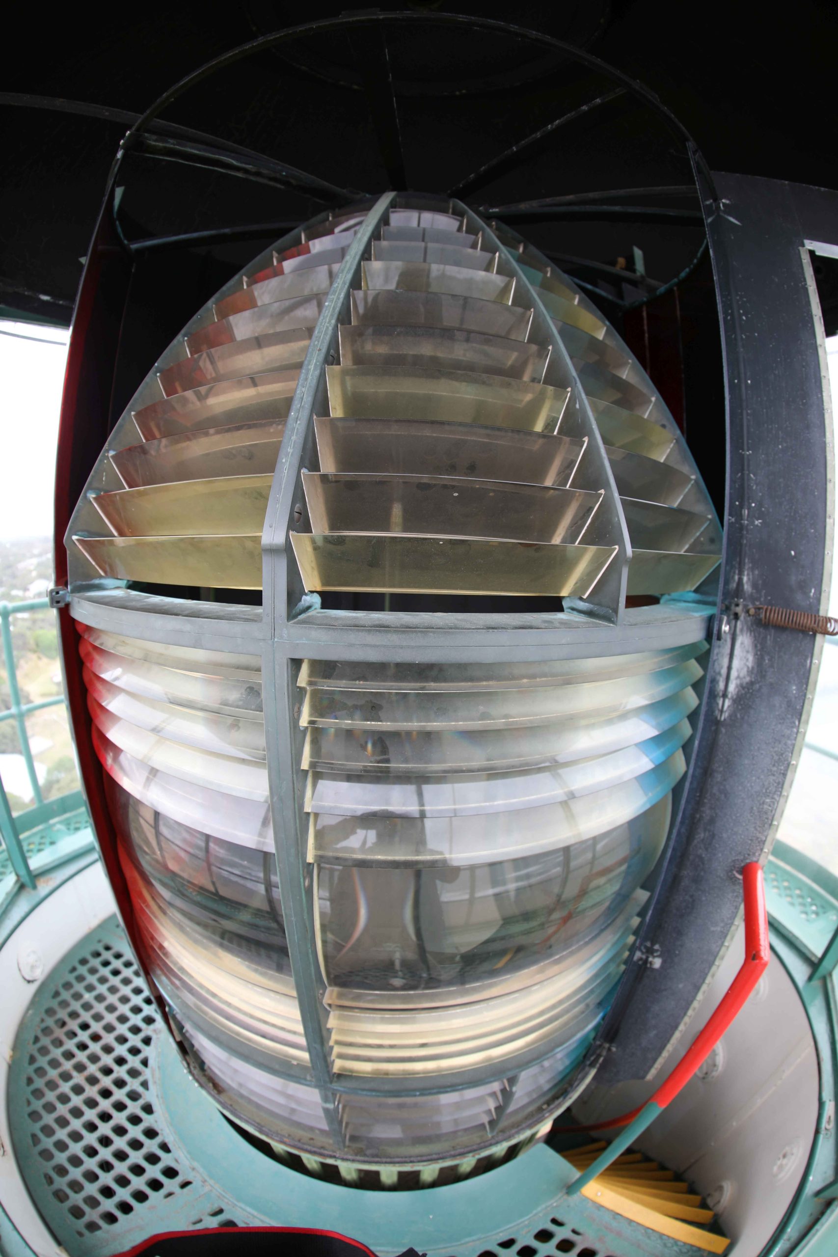
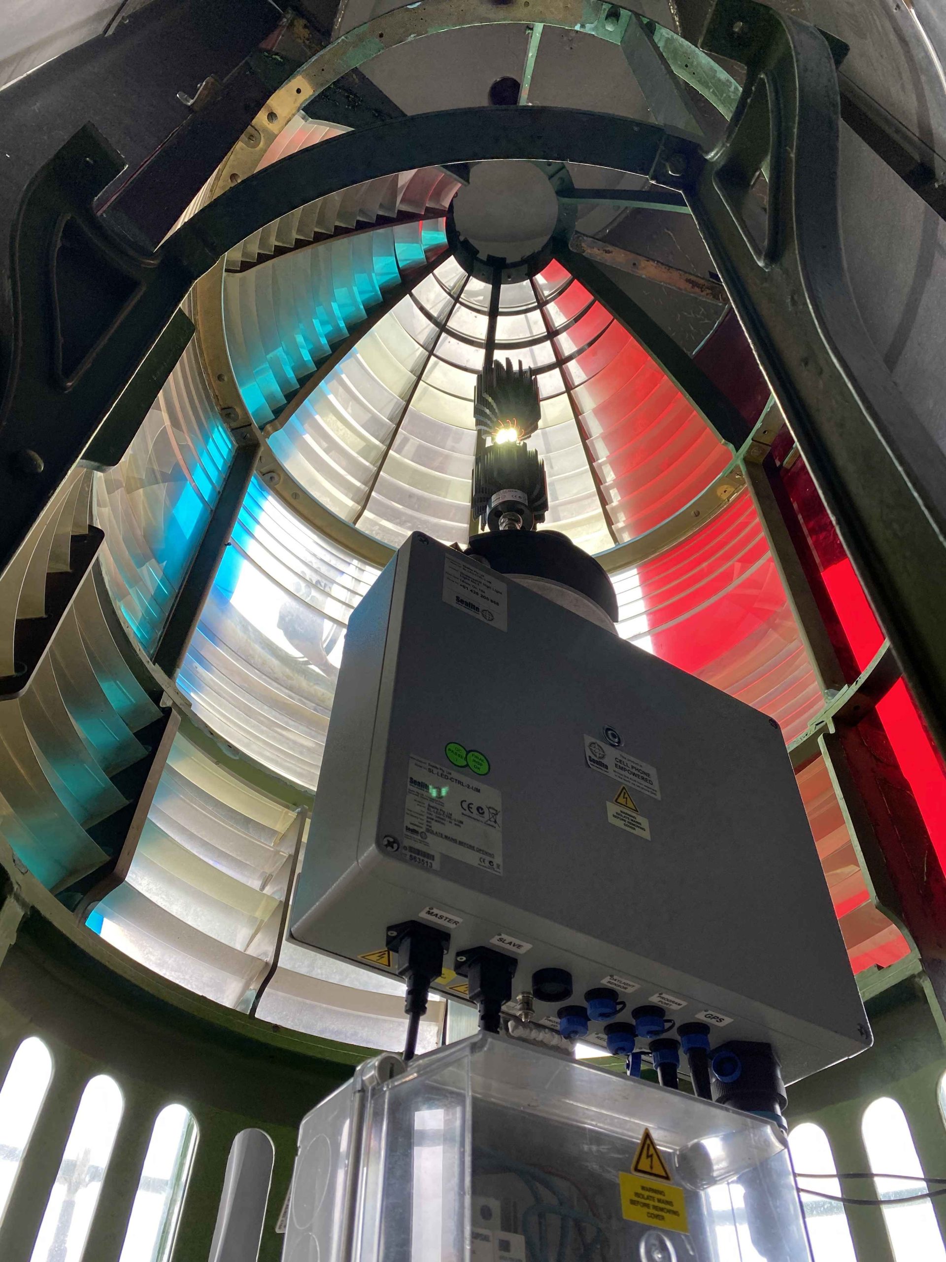
| Current Optic | Chance Bros 3rd order fixed |
| Automated | 1934 |
| Demanned | 1934 |
| Construction | Concrete |
| Height | 21.3 metres |
| Elevation | |
| Range | 14 NM (White) 7NM (Red) |
| Character | Flashing (2) 15secs |
| Intensity | |
| Light Source | Sealite SL314 LED array |
| Power Source | Mains supply |
| Operator | VIC Ports |
| Custodian | VIC Ports |
| Notes |
NB: Information is historical data and is not for navigational purposes.
Access
The lighthouse is a public reserve accessible by road and walking to the south of the Point Lonsdale township.
Tours
The Lighthouse was being opened regularly on Sundays. Check with the Queenscliff Maritime Museum. ![]()
Accommodation
No lighthouse accommodation is available
Museum
Queenscliff Maritime Museum ![]() has many Lighthouse artifacts
has many Lighthouse artifacts
You must be logged in to post a comment.